Tags
Relevant Tags
All Tags
- Ag Consultant Training (2)
- Best Management Practices (BMPs) (1)
- Blank Template (5)
- CCA (1)
- CIA Tour 2019 Announcement Template 070319 (2)
- CIA Tour 2019 Template (17)
- CIA Tour (1)
- CIA Tours (3)
- CIA2022 (2)
- CIA2023 (1)
- CTIC Demo (1)
- CTIC Projects (6)
- CTIC Staff (1)
- Carbon (1)
- Conservation in Action NEWS (36)
- Conservation in Action Tour 2017 Abstract Author (4)
- Conservation in Action Tour 2017 Abstract CA (2)
- Conservation in Action Tour 2017 Abstract Reviewer (1)
- Conservation in Action Tour 2017 Abstract Submitter (1)
- Conservation in Action Tour 2017 Moderator (2)
- Conservation in Action Tour 2017 Registrant (1)
- Conservation (1)
- Conventional Agriculture (1)
- Cover Crop Report Announcement (2)
- Cover Crop Survey (1)
- Cover Crops (10)
- Current Projects Navigation (5)
- Data_Cropland (2)
- Data_Grassland (2)
- Demo_copy (1)
- ED Announcement (9)
- Email Blast (1)
- Environment (1)
- Environmental Management (5)
- Home Resource (4)
- Hypoxia (1)
- In the news (9)
- Indian Creek Watershed Project (6)
- Manure Management (4)
- Membership Drive 2018 (1)
- NARS National 2019 (1)
- NARS (6)
- News from CTIC (17)
- Nitrogen (1)
- No-Till (2)
- Nutrients (1)
- OpTIS Webinar Announcement (2)
- OpTIS (1)
- Organizations (3)
- PLUS-UP Newsletter (54)
- PLUSUP (6)
- Partners - NEW (11)
- Partners Magazine Article (2)
- Partners (1)
- Planner (6)
- Presentation (6)
- Press Release (8)
- Projects (10)
- Publication (3)
- Reminder 2022 (1)
- Research (1)
- Rivers, Streams (1)
- Software (2)
- Soil Management (2)
- Tillage (1)
- Tour 2021 - Video (2)
- Tour1 (1)
- Video (1)
- Watershed (1)
- Wetlands (1)
- Yield (3)
- agro-ecosystem (1)
- economic benefits (4)
- economic profitability (4)
- newsletter_cover_crops (1)
- newsletter_news_releases (1)
- on-farm research (1)
Filtered by : OpTIS Webinar Announcement
| Results2 articles found. |
|---|
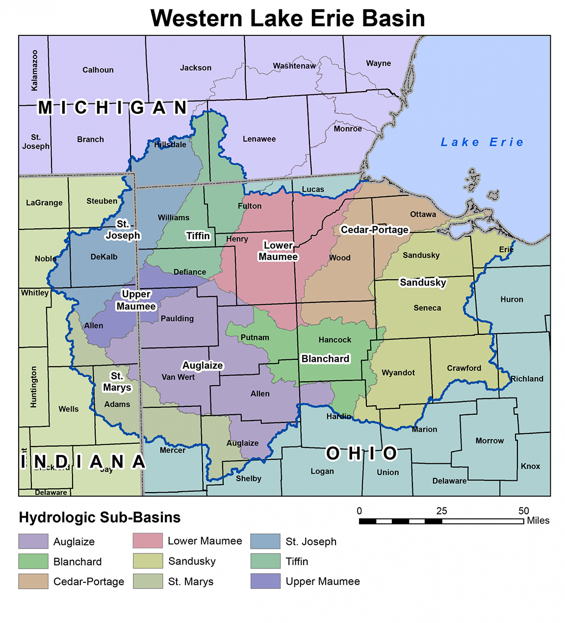
FREE WEBINAR ON USING SATELLITE DATA TO MODEL WATER QUALITY, APRIL 26 NOON EDTFREE WEBINAR ON USING SATELLITE DATA TO MODEL WATER QUALITY, APRIL 26 NOON EDT A free webinar on Wednesday, April 26, 2023 at 12:00 pm EDT will feature key insights from researchers using data from the Operational Tillage Information System (OpTIS) to help model water quality. Register here for the webinar and question-and-answer session with the panel. Speakers during the live, hour-long "OpTIS 3.0: Unlocking Water Quality Insights" program will include: Dr. Asmita Murumkar, The Ohio State University, using OpTIS data on tillage and cover crops in their modeling work in Ohio's Upper Scioto River watershed and Maumee basin. ... |
OpTISThis is your chance to get a (virtual) front row seat for the latest OpTIS research updates! Since you last joined us for an OpTIS webinar, we’ve added data for 2019-2020 and even more states. We’ll be joined by Prof. Roderick Rejesus of NC State as he’ll describe how he used remote sensing data from OpTIS to study the impact of crop insurance programs on cover crop use. The Operational Tillage Information System (OpTIS), a Regrow technology (https://www.regrow.ag), uses satellite data and a sophisticated algorithm to monitor conservation ... |