Viridis View | Conservation Benchmarking Collaborative
Tracking Progress for Regenerative Agriculture
 The Conservation Technology Information Center (CTIC) is proud to organize and lead Viridis View, a novel conservation benchmarking collaborative designed to improve the measurement, understanding, and application of conservation practice use and outcomes across U.S. agriculture.
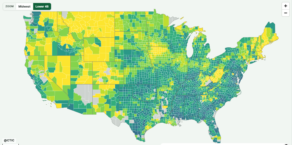
The Viridis View Data Viewer provides county-level Earth observation data on cover crops and tillage intensity. Data are provided for row crops in the Lower 48 states in the years 2015-2025 from multiple data providers: DTN, Iowa State University, Regrow, Terion AI, and TerraDiagnostics.
The Viewer is a powerful visualization tool that employs open-source coding practices to allow users to easily explore newly available datasets.
Building on CTIC’s 45-year history of leadership in agricultural conservation data and collaborative partnerships, Viridis View seeks to create a trusted framework for evaluating conservation progress at multiple geographic scales. The initiative will help answer important questions about where conservation practices are expanding, how use is changing over time, and how conservation investments can be more effectively targeted to achieve environmental outcomes.
Viridis View has two primary objectives:
#1
To provide near-real-time, public datasets of county-level adoption of conservation tillage and cover crops from 2015-2030 featuring remote sensing-based estimates from multiple groups across several geographies;
#2
To collaboratively and pre-competitively improve the accuracy of these estimates by assembling accessible ground-truthing datasets. The University of Maryland/NASA Acres will facilitate and help to manage these confidential data contributions.
Why Now?
Conservation in agricultural systems is at a pivotal moment, with a multi-year decline in commodity prices and a stressed ag economy, generational turnover in farm operations, federal funding pauses, contract cancellations, and new program rollouts. Recent years have seen major changes in the scale and sources of new public and private investments to promote the adoption of regenerative practices, including a $700 million announcement from USDA in December 2025. However, the most recent USDA AgCensus (published in early 2024) suggests that the rate of adoption of one key practice, cover crops, has actually slowed in recent years.
Despite the significant public and private investments into promoting and incentivizing the adoption of conservation practices, stakeholders are currently limited to the AgCensus (released only once every five years) to learn whether the investments have moved the needle at the landscape level. Collectively, the nation invests billions of dollars in such practices, but are we making sufficient progress in the key geographies at the rate needed to accomplish visionary goals?
The Viridis View Conservation Benchmarking Collaborative is underway to help answer this critical question. CTIC and its partners feel that there is an urgent need for greater collaboration across the entire conservation and ag tech community, including data scientists now using machine learning and other advanced methods to process remote sensing data in order to track conservation trends in near real-time.
Additional Development and Collaboration Opportunities
- CTIC is calling on industry collaborators to contribute baseline datasets to ground-truth the data-viewing platform
- Feedback and suggestions on the viewer is welcome as additional functionality is being developed for early 2027
- CTIC Membership provides an opportunity to have a seat at the table to help build the most comprehensive data-driven progress viewer for foundational regenerative practice adoption
For more information on how to support Viridis View and become a CTIC member organization, contact CTIC Executive Director Ryan Heiniger, [email protected], 319.768.8348
Methodologies
The Viridis View Data Viewer provides county-level data sets from multiple providers, including DTN, Iowa State University, Regrow, Terion AI, and TerraDiagnostics.
There are multiple ways to convert satellite spectral signals into cover crop presence and tillage intensity estimates. Each data provider in Viridis View has developed their own methods.
CTIC has crafted a Methods Overview to provide some background on the data-gathering process and remote-sensing variability. Additionally, each data provider has provided their Detailed Methods to explain their modeling.
Start by reading the Methods Overview, which includes a brief description of the methodological differences of each data provider, then dig into the Detailed Methods of each provider for more information on each data set.
Detailed Methods
User Guide
Learn about all the Viridis View Data Viewer’s complete features and functionality in the User Guide
Downloads
We anticipate downloads of the full data sets will be available in early 2027, and we’re continuing to add other features and functionality to the Viridis View platform.
If you have feedback, suggestions for additional functionality, or want to collaborate on additional data sets, including ground-truth data, please complete our Feedback Form.
Our Data Partners


Viridis View is made possible by the generous support of the Walton Family Foundation. Learn more about its sustainable agriculture programs at waltonfamilyfoundation.org.